Medium- or high-volume streets located along Goods and Services Corridors.
Description
Mixed Use Commercial Connectors are medium- or high-volume streets (typically 5,000-20,000 average daily traffic) located along Goods and Services Corridors (as identified in the Minneapolis 2040 Plan). These streets generally have high walking and bicycling demand, transit routes, and serve medium distance connections across neighborhoods, to commercial destinations, and often to the regional highway system.
Examples include West Broadway Avenue North, Central Avenue Northeast, and Lake Street.
Typical Characteristics
|
Miles
|
~86 miles
Approximately 8% of total street centerline mileage
|
|
Right of Way Width
|
Mostly 80’, 66’, or 100’
|
|
Effective Right of Way
|
Varies widely; mostly between 59’ and 100’
|
|
Functional Class
|
Mostly Minor Arterial; some Collector
|
|
Jurisdiction
|
- Hennepin County (majority)
- City of Minneapolis (some)
- MnDOT (a few)
|
|
Route
|
County State Aid Highway, Municipal State Aid, or State Trunk Highway
|
|
Modal Network
|
- Pedestrian Priority Network (all)
- Transit routes (all)
- Transit Priority Projects (many)
- All Ages and Abilities Bikeway (some)
- Truck Route (most)
|
|
Snow Emergency Route
|
Yes
|
|
Historic Street
|
No
|
Typical Design and Operations
See Street Design Guidance chapter for more information
|
Sidewalk
|
- 6’-10’ recommended pedestrian clear width depending on pedestrian volumes, intensity of adjacent commercial land uses, and other demands in the right of way.
- 2’+ frontage width to any obstructions; wider frontage zones should be considered when appropriate to support transit shelters, sidewalk cafes, retail displays, landscaping, or other features that make the pedestrian environment more attractive.
See sidewalks guidance for more details.
|
|
Boulevard and Furnishing
|
- 6’+ recommended width, including 8”-14” wide curb
- Wider boulevard and furnishing zones should be used when feasible to support features that make the pedestrian environment more attractive and comfortable, support tree health, and maximize green stormwater infrastructure.
- Effort should be made to include 5’ of space on both sides of the street to support healthy street trees, green stormwater infrastructure, space for snow storage, and to provide separation between pedestrians and motor vehicles. See street trees guidance for more details. If needed, these strategies should be considered, in combination as needed, to support healthy trees on both sides of the street:
- Eliminating parking from one or both sides of the street;
- Provide midblock curb extensions to provide space for trees in between parking spaces;
- Using a 6’ sidewalk clear zone width; or
- if trying to fit trees in with 4.5’-wide boulevard, work with the Park Board Forrester to ensure that the types of trees planted will have a higher likelihood of survival and less disruption to the sidewalk in narrower boulevard.
- If tree-supporting boulevards are still not feasible on both sides of the street, narrow or eliminate the boulevard from one side of the street to make enough space on at least one side of the street. Greening should still be used in the narrowed boulevard if possible.
- In commercial nodes, consider sections of paved boulevard when appropriate to support sidewalk cafes and higher volumes of pedestrians.
See boulevards and furnishings guidance for more details.
|
|
Bikeway
|
For street reconstruction projects on the All Ages and Abilities bikeway network, sidewalk-level protected bike lanes should generally be used. Protected and unprotected bike lanes can be considered for retrofit projects
|
|
Transit
|
- Frequently have local bus service and bus rapid transit routes.
- Local bus stops or bus rapid transit stations should be used accordingly.
- Bus-only lanes and other transit advantages should be considered for Transit Priority Corridors.
|
|
Freight
|
Most Mixed Use Commercial Connectors are on the Truck Route Network; periodic truck traffic will happen on all streets.
|
|
Roadway
|
- The roadway typically includes 2-way traffic, although includes several one-way pairs.
- The roadway should generally be limited to one travel lane in each direction with turn lanes as appropriate at intersections. Two lanes in each direction may be appropriate in some cases, but four-lane undivided streets should be avoided. If two lanes in each direction are included, they should frequently be done in combination with off-peak parking and loading zones. More than two lanes in each direction should only be considered in combination with bus-only lanes or off-peak parking.
- Standard roadway widths include:
- 10’ traffic lanes
- For streets with high-frequency bus service or heavy semitruck volumes, one travel lane of 11’ in each direction may be considered. Curb adjacent traffic lanes should not be wider than 10’ given the adjacent gutter pan.
- 2’ gutter pans
- For streets with constrained right of way, designers can consider 1’ gutter pans or an integral 11’ wide concrete lane. Flooding concerns may make narrower gutter pans infeasible; coordinate with Surface Water and Sewers.
- 1’ gutter pans adjacent to medians when there are no catch basins
- 10’ turn-only lanes
- For turn lanes with heavy bus or heavy truck volumes, 11’ may be considered.
- Details on bus-only lanes are available here.
- 8’ parking lanes or other curbside use (including gutter)
- In addition to vehicle parking, this area may include other uses such as loading and unloading zones, drop-off zones, bicycle corrals, parklets, street cafes, and greening. See vehicle parking and curbside uses guidance for more detail.
- 8’ bus stop pull out
- 6’+ medians
- Medians greater than 6’ provide an accessible pedestrian refuge space
- Consider widths greater than 8’ along major bike crossings to provide adequate refuge space for bikes
- 4’ medians can be considered in constrained right of way
- Medians should include greening when feasible
- Lane markings should be included and parking lanes should be striped
|
|
Design speed
|
25 mph
See design speed guidance for more detail.
|
|
Design vehicle
|
Most commonly SU-30, but can also be WB-40 depending on intersecting street and context.
See design and control vehicles guidance for more details.
|
|
Control vehicle
|
Most commonly Aerial Fire Truck Mid Mount 100, but can also be WB-62 depending on intersecting street and context.
See design and control vehicles guidance for more details.
|
|
Motor Vehicle Property Access
|
-
New driveways should be limited to locations without alley or cross street access.
-
Designers should explore removing driveways that are no longer being used, are no longer permitted, or where access is provided via an alley. Designers should also explore right-sizing driveway curb cuts.
See driveways guidance for more details.
|
|
Intersection Traffic Control
|
Signal control or stop control
|
|
Intersection details
|
- Curb extensions should generally be used whenever there is full-time parking.
- Raised pedestrian crossings should generally be included whenever the Mixed Use Commercial Connector crosses an Urban Neighborhood street, especially if there is a protected bike lane or high pedestrian use.
- When intersecting a neighborhood greenway or high-volume pedestrian crossing, include crossing improvements. Options include traffic signals, bicycle and pedestrian safety islands, curb extensions, and/or Rectangular Rapid Flashing Beacons. See NACTO’s Urban Bikeway Design Guide for additional options and details. Coordinate with Traffic and Parking Services to consider appropriate treatments at a given location.
|
Typical Cross Sections
Figure 2.7.1:
2-way Mixed Use Commercial Connector street with 1-way protected bike lanes and bus stops (80’ effective right of way)
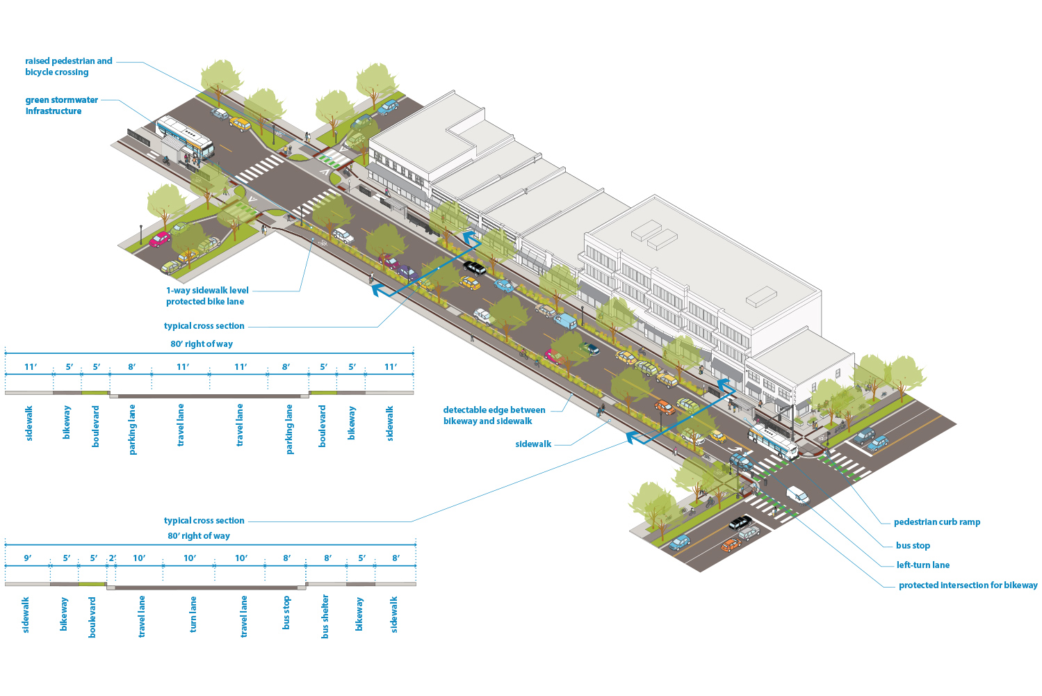
Download Figure 2.7.1
Figure 2.7.2:
2-way Mixed Use Commercial Connector street with bus-only lanes (86’ effective right of way)
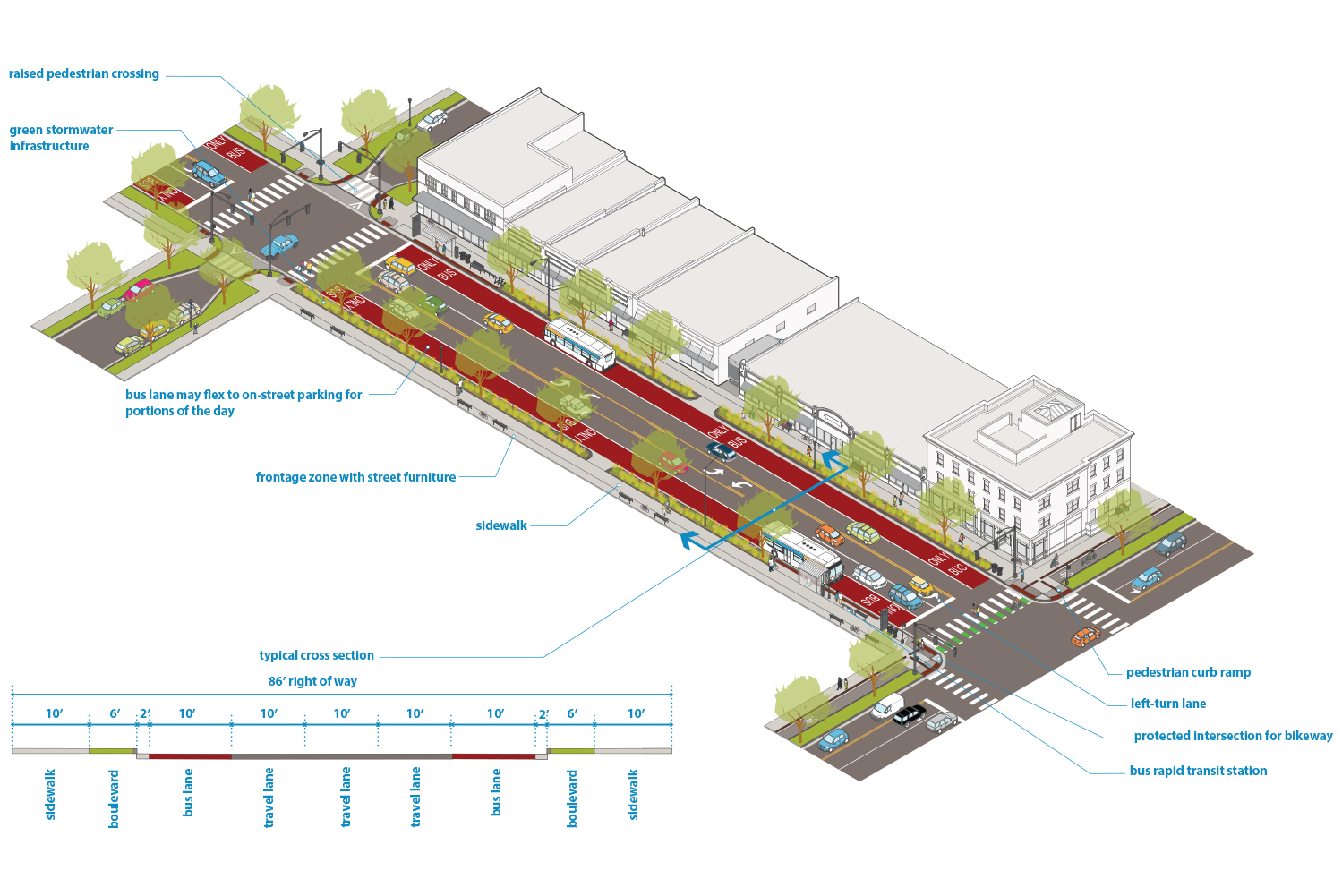
Download Figure 2.7.2