2.1B Typical Characteristics
Introduction
In this chapter, each street type includes a description, typical characteristics, typical design and operational features, typical concepts, and links to design guidance. The concepts reflect existing right of way widths commonly found in Minneapolis and are intended to inform project concepts and preliminary designs. The typical concepts support the City’s Complete Streets Policy, Vision Zero commitment, greenhouse gas emission reduction goal, mode shift goal, commitment to racial justice, and stormwater management requirements. Where applicable, they include specific modal features, such as bikeways and transit lanes, and operational alternatives, such as one-way and two-way roadway options.
The typical concepts reflect a fully reconstructed street and are not intended for smaller scale street retrofit projects. The street design guidance outlines more details to inform street retrofit projects. Typical concepts do not reflect exact conditions and are not intended to be used for construction. Street character, modal networks, right of way width, and topography vary across the same street type and preexisting conditions (e.g. encroachments) may limit use of the full right of way. Evaluating concepts must follow a decision-making process consistent with the City’s Complete Streets Policy – prioritizing people as they walk, roll, bicycle, and take transit over driving, deliveries, and parking.
Street Zones
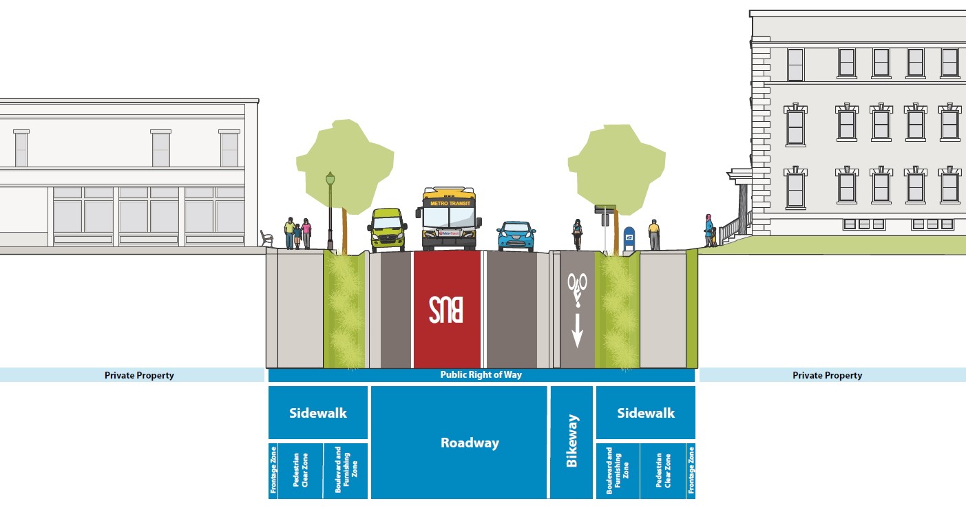
Design guidance for each street type is organized by zones (see Figure 2.1A.1):
- sidewalk zone, which includes frontage, clear, boulevard, and furnishing;
- bikeway zone, which may be in the roadway or adjacent to pedestrian zone; and
- roadway zone, which includes travel lanes, parking and loading/unloading lanes, curb and gutter, and medians.
The zones provide distinct spaces where similar street users and uses typically gather, move, or operate and provide a critical framework for design guidance. The typical concepts for each street type include dimensions for each zone to inform project concepts and preliminary design. The width and uses of the zones may change along a street segment or vary by time of day based on land use context and demands. For example, the loading zone may change to a curb extension at an intersection or a parking lane may change to a transit only lane during peak periods.
Figure 2.1A.1:
Street Zones
Sidewalk
Street ZoneThe sidewalk zone is typically located directly adjacent to the edge of the public right of way. Sidewalks serve as the backbone of the pedestrian network and support access between private property and streets. Sidewalks are for people to walk or gather. Bicycles may legally use the sidewalk zone in limited locations outside of business districts. Motor vehicles also may need to travel across the sidewalk zone to access private property via driveways or alleys. The sidewalk zone is divided into three subzones: frontage, pedestrian clear, and boulevard and furnishing.
Frontage
Street ZoneThe frontage zone is located immediately adjacent to the edge of the public right of way. This zone provides space for street users to access land uses and serves as a buffer between the pedestrian clear zone and buildings, structures, or elevation changes. Potential uses in the frontage zone include landscaping, transit shelters, retail displays, sidewalk cafes, or other features that make the pedestrian environment more usable, comfortable, and attractive. Along streets with commercial uses, consideration should be given to space for sidewalk cafes in the frontage zone in accordance with Process and Criteria for Sidewalk Café Licenses.
Pedestrian Clear
Street ZoneThe pedestrian clear zone is located between the frontage zone and boulevard and furnishing zone. This zone provides space for pedestrians to travel along streets and must be kept clear of obstructions, vertical discontinuities (e.g. maintenance hole or utility covers that protrude up), slippery surfaces (e.g. tree grates or other slick metal), and non-compliant cross slopes. The pedestrian clear zone serves as the Pedestrian Access Route, as defined by the Americans with Disability Act of 1990. The Pedestrian Access Route ensures a minimum passable space for those using mobility devices such as wheelchairs and provides predictability for those using other devices such as canes.
Boulevard and Furnishing
Street ZoneThe boulevard and furnishing zone is located between the pedestrian clear zone and roadway or bikeway zone. This zone provides space for many activities: space for pedestrians to gather or wait for transit, street trees, landscaping, green stormwater infrastructure, furnishings, snow storage, sidewalk cafes, signs, wayfinding, street lights, street signal infrastructure, utility cabinets, bicycle and scooter parking, charging stations for electric vehicles, and the curb. This zone also provides separation from people walking and motor vehicles.
Bikeway
Street ZoneThe bikeway zone is typically located between the sidewalk zone and roadway zone. Unprotected bike lanes are typically located in the roadway zone. The bikeway zone provides space for people riding bicycles and low-powered vehicles to travel along streets and must be kept clear of obstructions. The bikeway zone may include buffers that overlap with the boulevard and furnishing zone.
Roadway
Street ZoneThe roadway zone is typically located in the center of the right of way. This zone provides space for people traveling in transit or motor vehicles. People riding bicycles and micromobility also share this space in many locations. The edges of this zone often provide space for motor vehicle parking, stopping buses, loading and unloading, or parklets and bicycle corrals. Gutters and catch basins are also included at the edge of the roadway zone; they provide critical space for conveyance of stormwater and are generally not considered functional travel space for vehicles. The roadway may contain multiple marked or unmarked travel and parking lanes, including special use lanes like turn lanes or transit-only lanes. The roadway zone is used by all street users to cross intersecting streets and may be used exclusively by non-motorized users during events. Trails and some concepts for Urban Neighborhood streets do not include conventional roadway zones that maintain space for motor vehicles.
Encroachments
Effective right of way space is important to understand early in the design process. Designers should consider how topography, adjacent land uses, and built form on private property interface with the public right of way. Actual right of way width and effective right of way can vary significantly due to permitted and non-permitted encroachments, such as existing buildings, retaining walls, staircases, doorways, areaways, and greening. Furthermore, it may not be practical or feasible to remove encroachments because of factors such as significant topography, historical preservation, impacts to structures, or project cost. If encroachments cannot be removed, the effective space to design may be more constrained than the actual right of way .
New Streets
Street types are assigned to all existing and known planned street segments in Minneapolis. If new street segments are proposed to be constructed, the City of Minneapolis Public Works Department will evaluate the proposed location and assign one of the street types based on the planned land uses and built form, typical characteristics, and anticipated uses. To support the City’s greenhouse gas reduction goals, streets that limit or prohibit motor vehicle access should be prioritized over streets that provide greater capacity for motor vehicles. After a new street is constructed, the street type map will be updated accordingly.