3.4I Neighborhood greenways: full greenways
Search Content
Download PDF
Print Guide
Introduction
A full neighborhood greenway adds a dedicated trail to an Urban Neighborhood street while limiting or eliminating access to motor vehicles. Full greenways can be implemented with a retrofit or street reconstruction project. Full greenways are considered All Ages and Abilities bikeways. There are two typical ways to implement full greenways:
- A 2-way trail adjacent to a street with limited/reduced motor vehicle access or parking; or
- A 2-way trail with no adjacent motor vehicle access.
General Design Considerations
|
Bicycle priority |
Neighborhood Greenways should prioritize travel by bicycle and disincentivize through travel by motorized traffic. |
|
Connections |
Full greenways should be part of a linear bikeway with logical beginning and end points, typically connecting to other bikeways on the All Ages and Abilities Network as they are installed. |
|
Combining with bike boulevards |
Full greenways may be used in combination with elements of bicycle boulevards depending on available right of way, community input, cost, availability of alley access, parking demand, and the need for green infrastructure to mitigate flooding. Some blocks may fully remove motor vehicle access, others may narrow the vehicular travel space by half and other blocks could primarily focus on intersection treatments such as curb extensions, median refuge islands, and traffic circles. |
|
Flood mitigation |
Full neighborhood greenways may also be used for flooding and stormwater management mitigation. |
Full greenway with limited local motor vehicle access
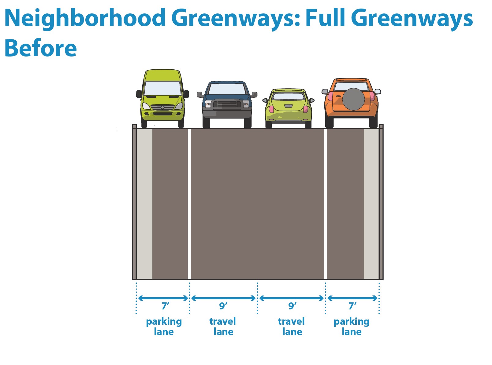
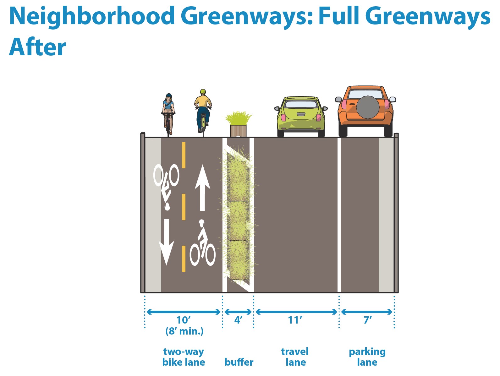
A full neighborhood greenway can be implemented by converting some of the existing roadway space to a 2-way trail separated from vehicle traffic by planters or delineators. This can be a good option for blocks on a neighborhood greenway route where fully removing motor vehicle traffic is not feasible or supported by community members.
Figure 3.4I.1:
Neighborhood greenway retrofit example
Design considerations if implementing with a street retrofit
Follow all appropriate guidance for delineator-protected bike lanes or planter-protected bike lanes.
|
Lane configuration |
Retaining one-way motor vehicle traffic with one-side vehicle is the preferred way to implement a full neighborhood greenway while retaining local motor vehicle access. On blocks with very low parking demand, a two-way street with no parking can be considered; this option is typically not preferred because it increases the risk that drivers will park in the bikeway.
|
|
Buffer zone width |
The buffer zone between 2-way bikeway and travel lane should be 2’-5’ wide if using delineators and 4’ wide or wider if using planters. |
|
Bikeway width |
The 2-way bikeway should be 10’-14’ wide, including the gutter pan. In constrained right of way, a 2-way bikeway of 8’ can be considered for short stretches. The bikeway will be implemented in the roadway. |
|
Manage parking in bikeway |
Consider elements that reduce the likelihood of drivers parking in the bikeway, including using planters rather than delineators, increasing delineator spacing, and including a delineator in the middle of the bikeway at access points. |
|
Diverters |
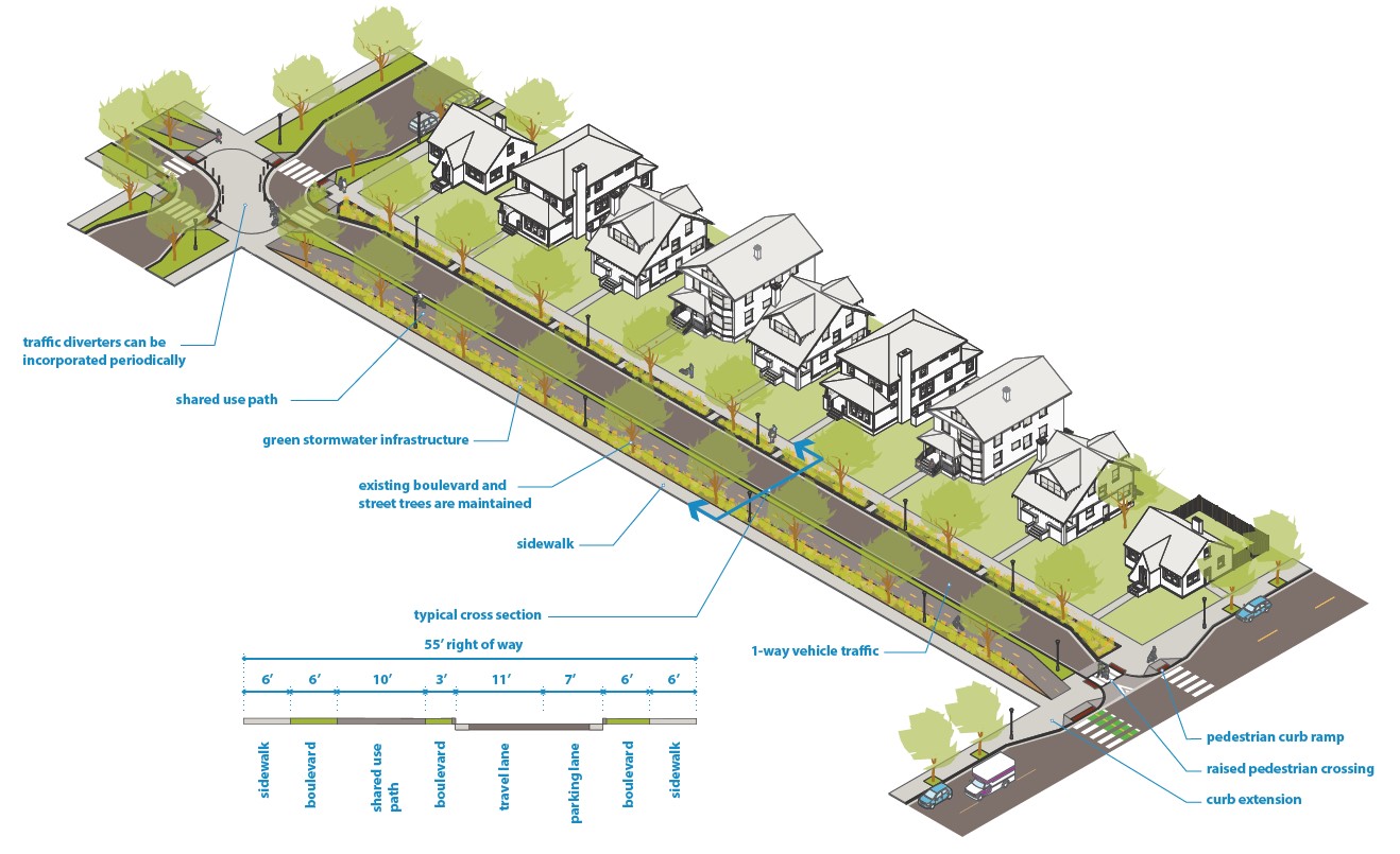
Consider alternating the direction of one-way traffic periodically to further reduce traffic volumes and allow the possibility of eliminating interactions between bicyclists and motor vehicles at intersections as shown in Figure 3.4I.2. |
|
Crossings |
Include crossing improvements for the bikeway at busier streets and consider at other streets; options include traffic signals, bicycle and pedestrian safety islands, curb extensions, and/or Rectangular Rapid Flashing Beacons. See NACTO’s Urban Bikeway Design Guide for additional options and page 5-15 of the MnDOT Bicycle Facility Design Manual for additional details on trail design at intersections. Coordinate with Traffic and Parking Services to consider appropriate treatments at a given location. |
Additional design considerations if implementing with a full or partial street reconstruction
Follow design considerations for neighborhood greenways with limited local vehicle access street retrofits.
|
Sidewalk-level bikeway |
The two-way bikeway should be implemented at sidewalk level and should typically be 10’ to 14’. The bikeway design should accommodate emergency and maintenance vehicle access. |
|
Green stormwater infrastructure |
Consider the best way to incorporate green stormwater infrastructure. That may be including a green buffer between the bikeway and the roadway or a slightly narrower paved buffer and a slightly wider boulevard area. |
|
Raised crossings |
Raised pedestrian and bicycle crossings should generally be included when the bikeway crosses an Urban Neighborhood street; curb extensions should generally be included whenever there is parking |
Figure 3.4I.2:
Neighborhood greenway example with 1-way traffic and 1-side parking
Full greenway with no adjacent motor vehicle access
A full neighborhood greenway can be implemented on a street that is closed to motor vehicles. This would typically be implemented in combination with flood mitigation improvements and/or park-like amenities as shown in Figure 3.4I.3.
Design Considerations
|
|
Designers should generally use the trail guidance to inform the design details for a full greenway with no motor vehicle access. |
Figure 3.4I.3:
Neighborhood greenway example with no adjacent motor vehicle access


